
Before the First Highways
Before the arrival of the Pilgrims in 1620 there were no roads in New England that could rightfully fit that description. Travel was mainly by boat and the ocean along the seacoast was the region’s “Main Street.” Not until Concord, founded in 1635, became the first inland village in New England, closely followed by Dedham in 1636 did any semblance of a highway appear. Actually both villages, settled by many of the original settlers of Watertown, found their future homes as a result of exploration by canoe along the rivers and waterways that led into the interior.
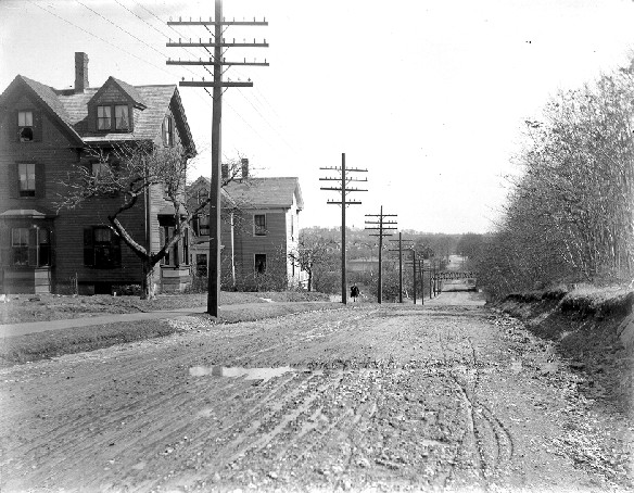
It is difficult to determine when the first highway in Newton wide enough to accommodate a wagon was built. Old maps indicate that what was perhaps the first road from Cambridge to Newton bears this notation, “ancient way to Nonantum – discontinued 1636.” This was replaced a few years later by a parallel road to the south. Early settlers of Newton found but few “highways” that led them to their future homeland.
Those from Watertown crossed the Charles River on a footbridge built in 1641 to follow a path that became the forerunner of the present Galen/Centre streets. The first of the pioneers starting out from Cambridge crossed the river by a ferry established in 1635 and followed a crude highway along its southern bank, passing through Little Cambridge (now Brighton). Restless Muddy River (Brookline) residents venturing westward moved in the opposite direction from that of their future neighbors from Watertown on the same path, later to be called the Post Road, while venturesome Roxbury settlers drifted into Newton using old Indian trails and a path later to be called the Dedham Road. Since none possessed a wheeled vehicle, no broad thoroughfares were required to aid their pilgrimage. Not until the early 1700s when the first cart bridges were built to span streams and ravines would wider highways be needed. As Indian trails became trodden paths and then cart roads, the farms and villages of Newton were slowly tied together. There were few major roads in the beginning that provided access to Boston.
The first settlers of Newton, finding but scattered pockets of enriched soil and not an overabundance of heavy stands of timber, turned to the raising of livestock, and their search for desirable pasture lands spread out the population of the new settlement over a wide area. While this required a number of cleared paths to tie them together, the cost of their maintenance taxed the meager resources of the residents and only a few major highways emerged until late in the seventeenth century. In addition, since there were no excess goods or produce available for trading, no sturdy four wheel vehicles were required and they did not appear in any great number until well into the nineteenth century. Crude two wheel farm carts and wheel-less “drags” were sufficient to work about the farm, and it would appear that historians state correctly that there were only three horse drawn carriages in Newton as late as 1800. Rural Newton had no need for them as Francis H. Kendal, writing quite some time ago in the New England Magazine, indicates:
To go back to the year 1800, we must imagine villages within the territorial limits of most of the towns of today, with but little manufacturing, the inhabitants being usually farmers, depending largely on the products of their own acres for their sustenance and comforts. Very seldom indeed was a journey as such distance undertaken by these rural inhabitants to obtain things of a different sort to add to labor for ‘wet and dry goods,’ such as molasses, sugar, tea, rum, and cloth other than homespun woven.
Before 1786, and long before Back Bay was filled in, every highway from Boston merged into a single road over the narrow Boston Neck into Roxbury, a passageway so restricted that high spring tides often swept over it. A “Parting Stone” at Roxbury marked a division of the highway into two branches, one called the Old or Upper Post Road, leading in a northwesterly direction toward Cambridge and Watertown. The Post Road took its name from the first postrider who bravely traversed the rough highway between New York and Boston in 1673. Another, called the Middle Post Road, took a westerly course to Dedham where another Parting Stone marked a division of this highway, one branch continuing westerly as the Middle Road and the other dropping off in a southerly direction toward Rhode Island and called the Lower Post Road. All three post roads – Upper, Middle, Lower – met at New Haven and continued into New York as a single highway.

The Upper Post Road divided at Brookline, one section proceeding to Cambridge and then crossing the Charles River over the Great Bridge which replaced the ferry on the same site in 1662 (now occupied by the Lars Anderson Bridge). The older section of the post road entered Newton through what is now Brighton, roughly following the course of Washington Street. In Newton it traveled but a few hundred yards through the village along present Galen Street before it crossed the bridge into Watertown. This was the first bridge built over the Charles River, constructed as a footbridge in 1641 and made a cartbridge in 1720. In Watertown this section of the post road was joined by the Cambridge branch and proceeded as one road through Wayland, Sudbury and points west. Its brief contact with Newton afforded the village one of its major highway connections with Boston.

Another was the Sherburne Road which joined the old post road at Brookline and gave the south side of the village access to Boston. Its course in Newton followed the route of the present Florence, Jackson and Clark streets, joining Centre Street (the old Dedham Road) and continuing to a point near the present Newton Highlands playground where it turned northwesterly to follow the course of the present split street (Curtis-Ramsdell) to a junction with what is now Elliot and Woodward streets (Elliot Street whose origin is described later was laid out before 1688). Sherburne Road, now bearing the name of Woodward Street, continued westward and entered Lower Falls over a route including sections of what is now Beacon and Washington streets. Crossing the river at Lower Falls and leaving Newton at a point called the “Wading Place”, it entered a section which later became Needham and still later part of Wellesley.
The third early highway of major importance, particularly to Upper Falls, was one called the Dedham Road. Its course followed very closely that of the present Centre Street as it proceeded from Newton Corner to Newton Centre and then to the corner of the present Curtis-Ramsdell streets (formerly Cook Street) and Centre Street. At this point it divided, one branch continuing southwesterly past the old South Burial Ground where it turned abruptly south to form a branch, appropriately now called Dedham Street, which finally left the town near the old Brook Farm at the West Roxbury line. Back at the fork a branch of this road called the Sherburne Road (previously described) proceeded a short distance in a westerly direction along what was Cook Street where it split, Elliot Street running off to the west and the Sherburne Road continuing on to Lower Falls. Elliot Street passed through Upper Falls crossing the river into Dedham, later Needham. On the south side of this highway within the village another road branched off and ran in a southwesterly direction down across the present railroad tracks to the river, close to what is now Williams Street. Part of this road remains today as Mechanic Street.

At a point downhill on Elliot Street, at about the entrance to Sullivan Avenue, the street makes a slight turn to the left. Originally the old road continued more or less on a straight line to John Clark’s sawmill built in 1688, the first mill on the river in Newton. Later it crossed the river into Dedham at a “fordway” and then circled to the left to join what is now Central Avenue. When the Robert Cook stone bridge was built in 1714 over the river a short distance upstream, the old road (Elliot Street) was altered to lead to the bridge while the abandoned section of highway continued to serve as a private road to the mill (see first page of “INDUSTRY” chapter). About 1823 it was converted to a right-of-way when some of Simon Elliot’s small mill buildings, built in the 1780s, were removed to make way for the new brick factory buildings of the Elliot Mfg. Co. After the mill buildings were converted to worker’s tenements they were placed alongside the right-of-way.

east towards present day Chestnut St.

Chestnut St.
The right-of-way remains today as material evidence of an official action of the village of Cambridge that recognized Newton’s pending separation in 1688. It began when Newton was pressing Cambridge to allow it to become an independent village, and in anticipation of their petition being granted, the people elected a town government of their own. However, they needed financial assistance from the parent village for the construction of a much-needed highway for the use of both parties and the following action was the result:
“1687 – John Ward and Noah Wiswall were joined to our Selectmen to treat with the Selectmen of Cambridge to lay out a highway from our meeting house to the Falls.”
That Cambridge acquiesced to their request is evidenced by an agreement, the first known document passed between the parent town of Cambridge and Cambridge Village (Newton) about the time of their separation, which began:
“Articles of Agreement, made September 17, 1688 between the Selectmen of Cambridge and the Selectmen of Cambridge Village, in behalf of their respective towns – “
And for the purpose that the new villagers:
“Bear their proportion in the charges in the upholding and maintaining of the great bridge and school, with some other things of public nature in the town of Cambridge – “
The agreement goes on further to say:
“…for the end above said that the village shall pay to the town of Cambridge the sum of 5 pounds in merchantable corn, at the former prices, at or before the first day in May next ensuing the date above, in full satisfaction of all dues and demands by the said town from the said Village, on account above said from the beginning of the world to the 11th January, 1687. Provided always, and it is to be hereby understood, that the town of Cambridge, in consideration of 4 pounds of current county pay, already in hand payed to the Village above said, shall have free use of the highway laid out from the Village Meetinghouse to the Falls forever.”
Evidence of compliance with this agreement is indicated by this Cambridge record of April 30, 1689:
“Received of John Clark (Upper Falls sawmill owner) Constable of New Cambridge, 5 pounds in corn at the common price; that is, Rye at four shillings the bushel, Indian at three shillings, and Oats at two shillings the bushel.”
The term “merchantable corn” appears to have covered several varieties of grain. It is interesting to note that the agreement is addressed to the Selectmen of Cambridge Village but was signed by John Spring, Edward Jackson and James Prentice as Selectmen of New Cambridge indicating the change in the new village’s name.
There is no doubt that this forerunner of what is now Elliot, Street bore the most traffic, by foot or horseback, of any of the early highways of Newton. Clark’s sawmill, and later the grist and fulling mills, were among the few enterprises in town, and aside from the church in East Parish (Newton Centre) attracted the most attention of the town’s residents. On the Dedham side of the river homes began to spring up along the old county road that extended westward through Dover and other communities. One would find that many of these houses built in the first days of the eighteenth century contained timbers bearing the marks of John Clark’s saws since Cook’s Bridge over the Charles River made the sawmill at Upper Falls quite accessible.
In 1725 a rate of 40 pounds was allowed for the work of repairing the highways. As every resident was taxed to build and maintain the highways of the village, the town later provided a way for a man to work off his debt at the rate of three shillings per day for his labor and six shillings for a man with and a team, as indicated by the following:
“March 3, 1760 – Voted, that every person shall have liberty to work out their highway rate the present year; that every person shall have three pence per hour for their labor in said ways the present year; and there shall be allowed for each team that is able to carry a ton weight three pence per hour for their labor in said ways.”
The Turnpikes
The Industrial Revolution following the Revolutionary War forced a new nation to seek ways and means to manufacture its own supply of hard goods which previously had been procured in England. Water power to drive mill wheels was a vital need and Newton found itself blessed by having a source near at hand; the Charles River. Natural falls in the river at Upper and Lower Falls thrust these two villages into an important position in the town. When heavy raw and finished goods were produced which necessitated foreign and domestic shipments by sea, the need arose for a direct highway from the mills to the docks at Boston. However, this need was not as acute for the farmers who did not receive benefits from the mills, and the demand for new taxes to finance the road to satisfy only the mill owners was not a popular one, particularly where the people were still reeling under the burden of taxes imposed on them for the cost of the recent war.
Therefore, the proponents of the project sought to make it a private highway, a toll road built from private funds through the sale of stock. This was the manner in which most states were financing their roads following the revolution.
By 1810, almost 200 turnpike companies were incorporated in Massachusetts alone, with almost 100 in New York and about 20 in Pennsylvania. At that time the best roads cost $5,000 to $10,000 per mile. One of the first toll roads was the stone surfaced Lancaster Pike between Philadelphia and Lancaster, Pennsylvania. About 60 miles in length, it was built between 1792-1795 at a cost of $465,000. Not until 1886 did Congress authorize a Federal highway. This was the National, or Cumberland Road, from Cumberland, Maryland to Wheeling, West Virginia.
The Worcester Turnpike was finally underwritten by a Boston group. It was not the first attempt. It began as a dream of Levi Pease who had pioneered the first stagecoach runs over the old post road from Hartford, and later from New York to Boston. In 1796 his name appeared at the head of a list of “thirty-one solid citizens as incorporators” of one of Massachusetts’ first turnpikes. Now one was to be laid out from Boston to Worcester by way of Shrewsbury, the town, incidentally, where he had bought the Farrar Tavern in preparation for his retirement. It was small enough reward for this remarkable man. Since his first through mail coach arrived in New York in 1784, the time for carrying the New York to Boston mails had been reduced from six days to 36 hours! In the early 1830s when Downing and Abbott’s Concord Coach had reduced this time to 24 hours and “bells were rung and bonfires blazed along the route”, However, Levi Pease could not share in the celebration as he had died in 1824 at the age of 84.
Worcester Turnpike’s stock consisted of 600 shares at the par value of $250 each, actually a small amount of money since the estimated cost of the approximately 40 miles of highway was less than $4,000 per mile. Sixteen of the shareholders were from Newton, and included Upper Falls manufacturers David Ellis of the Newton Factories and General Simon Elliot, of the Elliot snuff mill interests, as well as local residents Ebenezer Woodward, John Kenrick and two Newton Centre clergymen, Baptist minister Reverend Joseph Grafton and Reverend Jonathan Homer of the First Church. Surprisingly, farmer and landowner William Hammond was also a shareholder, although his hope was to persuade the others to change the proposed route to another part of town.

The original route of the pike was from Boston to Roxbury and thence to Brookline where the turnpike actually began. Its route was almost a straight line across Newton, mostly through uninhabited areas. In 1831 only the Parker family residence was located on the highway until it reached the outskirts of Upper Falls village. The distance to Boston was shortened in 1821 when the turnpike was connected at Brookline with the new road constructed over the Mill Dam which bridged the ocean and mud flats of Back Bay between Boston and Brookline. New and existing taverns lined the turnpike between Brookline and Upper Falls, commencing with the ancient Punch Bowl Tavern in Brookline, which marks the old entrance to the pike; then the old Richards Tavern on the Brookline-Newton line; next Mitchell’s Tavern in Upper Falls, (known as Marean’s in the 1700s) at the junction of the present Centre Street and Route 9; Cook’s Tavern at the junction of present Woodward Street, Elliot Street, and Route 9; the early nineteenth century tavern house on Boylston Street which was later occupied by James Cahill; and finally in 1829 the Ellis or Manufacturer’s Hotel which was built further up the hill. This made a total of four taverns on the turnpike in Upper Falls. Of course, others lined the roadway west of the village.
The hauling of large bales of cotton, heavy steel and other bulky loads between Boston and Upper Falls demanded strong wagons, and their use was probably influenced by the sight of ten-horse teams hauling Conestoga type wagons along this highway in 1812 when the war with England at that time found all the eastern seaports closed because of a blockade imposed by Great Britain. These heavily loaded wagons were dubbed “Madison’s Ships” after the president in office at the time. These sturdy vehicles were described as follows:
“These wagons had a boat-shaped body with a curved bottom, which fitted them specially for mountain use, for in them freight remained firmly in place at whatever angle the body might be. The rear end could be lifted from the sockets; on it hung the feed trough for the horses. On one side of the body was a small tool chest with a slanting lid. This held hammer, wrench, hatchet, pincers, and other simple tools. Under the rear axeltree were suspended a tar bucket and water pail. The wheels had tires sometimes a foot broad. The wagon bodies were arched over with six or eight bows, of which the middle ones were the lowest. These were covered with a strong, pure white hempen cover corded down strongly at the sides and ends. Four to six tons was the usual load for such a vehicle.
The driver rode on the nigh-wheel horse or walked, no seat being provided for him. A board projecting from the side between the wheels afforded a precarious seat for the helper, who generally worked his way for such employment.”
Various forms of sleds and sleighs were used for freighting over the turnpike in the winter. Undoubtedly, some were of the type called “board runners” since a single piece of hoard was used for the runner, the same being shaped to a suitable form for running over snow. All such sleighs or sleds were homemade or of local manufacture since they could be made easily by one familiar with carpenter’s tools.

Most of the traffic on the turnpike other than that generated by the mills came from outside Newton despite the generous exemptions from paying the toll, such as:
“…any person who shall be passing with his horse and carriage to or from public worship, or with his horse or team to or from any mill, or with his horse, team, or cattle to or from his ordinary labor on the farm, or on the common or ordinary business of family concerns within the same towns; or any person passing on military duty.”
Although it is difficult from the above to imagine who would be required to pay a toll, nevertheless we read of those who “shunned” the pike to avoid paying. For this reason perhaps, the early stagecoaches used the Weston road from Worcester through West Newton to pass through the town, although when the Downing-Abbott Concord Coach made its appearance in 1829 and eventually set the record of 24 hours for passage between New York and Boston, it was no doubt made over the Worcester Turnpike which was a shorter distance between these points. The elegant, smooth riding coach whose basic lines were copied from a similar carriage in England was far superior to the rather primitive mail and passenger coaches used prior to their introduction into this country. With its refined design and sturdy construction it could be hauled easily by a two-horse team except in extremely bad weather and poor road conditions.
Although stagecoaches were in use throughout much of the eighteenth century, they were rather crude and rough riding affairs compared to the Concord Coach. They did not encourage travel, particularly for any great distance, because of their hard riding and uncomfortable features. The mail stages in use around 1806 were described as follows:
“They were long machines, hung with leather braces, with three seats across, of a sufficient length to accommodate three persons each, who all sit with their faces towards the horses. The driver sits under cover, without any division between him and the passengers; and thence is room for a person to sit each side of him…the mail is placed in a box below the seat. There is no guard. The passengers’ luggage is put behind the seats, or tied on behind the stage. They put nothing on the top, and they take no outside passengers. The stages are slightly built, and the roof suspended on pillars; with a curtain, to be let down or folded up at pleasure.”
Nevertheless, they carried the mail providing service, particularly along Worcester Turnpike, that might have matched the frequency of today’s deliveries. Newton Upper Falls received such service as early as 1825 when its first post office was established and in 1826 when a messenger on horseback carried mail to Needham’s post office, first twice a week and later increased to three trips weekly. When the first stages made their appearance, our early villages located near access roads to Boston had once a day service to that town, usually a morning stage in and an afternoon one out. Of course, when the turnpike was built villages such as Upper Falls had direct access to the larger town which was augmented in 1834 by a stage that connected with the railroad which had reached West Newton that year. This accounts for the date of construction of Chestnut Street between Upper Falls village and West Newton depot.
The arrival of the turnpike in 1808 stimulated industrial expansion, which in turn called for more roads to accommodate the increased population and to provide access to newly built homes. A lane, later called Richardson Road, was added in the early 1800s for this latter accommodation. In 1818 there was a demand for a new school, and an extension of Chestnut Street was constructed from a point near the present Baptist Church to the turnpike where the school was located at the southwesterly corner of Chestnut and Boylston. In 1837 a “way, a lane later known as Winter Street” was laid out, along with the highway it joined at the top of Winter Street hill known as High Street.
When the Charles River Railroad reached Upper Falls in 1852, an extension of Chestnut Street was built from Elliot Street to the depot in order to provide easier access to its freight service by the Elliot Mills. Oak Street eventually joined it at the depot but was not extended southward from the rails to Needham Street until this later street was laid out in the 1870s. An 1874 atlas shows only two houses on the south side of the railroad. This same atlas shows the location of River Avenue, Pennsylvania Avenue, Cliff Road, Cheney Street and Chandler Place although they are not identified. Keefe and Sullivan Avenues, Hale Street, Ohio Avenue and Wetherell Street had not yet been built and there were, of course, no roads laid out on what is now Eliot Hill. However, not many years were to pass before all these were in place (with the exception of Eliot Hill) much the same as we see them today.
Bridges
We now turn our attention to the bridges that connect the village with other towns and hamlets across the winding Charles River. Our thoughts no doubt will immediately leap to the world famous Echo Bridge, but let us take them somewhat in chronological order. There are seven bridges in all to be considered, with almost 250 years separating the construction of the first from the last.
Cook’s Bridge
We begin with the lowly “cart bridge” with its ancient arches of granite, officially carried on city records as Cook’s Bridge but know to most as simply Elliot Street Bridge. The exact age of the bridge is not known but Clarke’s “History of Needham” contains the following, taken from Needham records:
“On Nov. 9, 1714, Sergeants Metcalf and Fuller with Eleazer Kingsbury were appointed to lay out a ‘Roade from Needham meetting houfe to the new bridg by ye houfe of Leuth Cook’”
(Note: original spelling retained.)

The bridge was named after Robert Cook who in the year 1700 bought “forty acres of land on the west side of the Charles River, just above the Upper Falls” from Nahaton, the Indian chief (see HISTORICAL section). In addition, we find the following comments from Clarke’s history (1914) regarding the bridge:
“Cook’s Bridge is the only ancient bridge that has lost its old name. It took its designation from Capt. Robert Cook, who was…one of the most prominent citizens of Needham from 1711 to 1756. In the early 1800s the Cook family removed from Needham and gradually the old name, Cook’s Bridge faded away, and ceased to appear on the records of Needham and Newton, but on March 16, 1903, by vote declared the names of the bridges, designating this one as Cook’s Bridge. On October 18, 1742, the town appointed Captain Cook, Robert Fuller, Eleazer Kingsbury, James Kingsbury and Jeremiah Eaton ‘to finish the Rebuilding one Halfe part of Cart Bridge over Charles River near Eliakim Cook’s’”
The repairs in 1742 coincided with a complaint made to Newton officials by local citizens regarding the condition of the bridge. Clarke further states that Needham records as late as 1897 call it Cook’s Bridge, and they also show that it was widened and partly rebuilt that year by Newton because of its proposed use by the Newton & Boston Street Railway Company which paid part of the $1,250 cost. The old bridge had gone through a previous widening in 1884 when Central Avenue in Needham was widened to 52 feet from the middle of the bridge to Hurd’s Corner, a distance of a half mile or more. A news item of Dec. 29, 1883 records this:
“The County Commissioners ordered the town of Needham to widen their end of the bridge, which is built of stone; but as there are three arches, it will be quite a difficult matter for Needham to accomplish, unless the city of Newton cooperates in this matter…”
Our correspondent further states that he believes a “harmonious understanding” was reached with Needham and concludes:
“It is not contemplated, however, to disturb the bridge this winter, but it is hoped the coming summer will not pass with this work uncompleted. It has been suggested that the bridge could be widened with wood, but that seems hardly practicable, although the first cost would without doubt be something less.”
It is believed that a compromise was reached later by eliminating a sidewalk on the south side and extending the north side sidewalk beyond the edge of the bridge, supported by wooden beams which would provide the required width. In line with the tradition that all ancient bridges must have a bit of folklore attached to them, one of our historians (Sweetser) dutifully contributes this tale:
“On this bridge fifty years ago (1839) the credulous countryfolk used to gather to watch for the ‘Baby Ghost”, a wee spectre whom they thought ran at times across the blue waters, while the rocking of its cradle they fancied could be heard beneath the stream.”
Sweetser goes on to say that the busy life of latter days has effaced the memory of this legend and its mysterious origin. However, we were able to solve the mystery when we ran across the story of this “ghost” in a news item appearing in 1882:
The Baby Ghost at Upper Falls Half a Century Ago
“In a letter received last week from an elderly gentleman, now a resident of Worcester, but a native of Lower Falls, he alludes to the fact of moving to Upper Falls when nine years of age, where he spent his youth, and dwelt with pleasure upon his recollections of many incidents of his life while there. He writes: ‘I have vivid recollections of the ‘ haunted house’. It stood near Charles River, and I recall the stories of a child having been murdered within its walls, and of noises and rockings of cradles heard nights, disturbing the slumbers of its occupants. And also the tales about a ‘baby ghost’ which appeared on a rock in the river opposite the haunted house. It was naked, and would rapidly pass back and forth from the rock to the water for an hour, and then disappear for the day. The ghost was about as large as a ten-months-old child. Hundreds vent daily to what was then called Needham Bridge, to watch it. All could see it pass back and forth from the rock to the water; no one saw it go away, but it always disappeared. The excitement for a week was fearful. Every one seemed to feel there was a connection between the baby ghost and the child of the haunted house. At this time I was twelve years of age. During the week, mothers would find their boys after dark, as they were afraid to remain out. After a few days a young man went to the rock to investigate, captured the ghost, and brought it to the crowd for inspection. It was found to be a piece of glass. The glass probably, had been carried to the rock and left there at high water, and the sun, when it got to the right elevation, would shine upon the glass, and the agitation of the water as it struck the base of the rock being reflected in the glass, produced the appearance of a ‘baby ghost’”.
The writer, However, prefers the following graphic description of this scene from the bridge, as observed by Sweetser:
“The bridge on Elliot Street gives pleasant views down the picturesque rocky and foliage-draped gorge, with its rambling old brick mills, and the white Baptist church on the cliff above; and on the other side opens a quiet cove, with meadows and coppices beyond, and in the distance gracefully rolling hills, whose brilliant foliage makes a symphony of scarlets and bronzes in the still days of October.”
Kenrick’s Bridge
Another ancient bridge on the southern perimeter of the old village which also has its share of incorrect identity is Kenrick’s Bridge, not Kendricks as it is currently called. It was named, of course, for one of the first settlers of the area, John Kenrick, who moved there in 1658. He purchased 250 acres along the river beyond the Haynes Grant, land formerly owned by Thomas Mayhew. Clarke, in his history, says this about the bridge:
“Kenrick’s Bridge is near the ‘Landing Place’, which is referred to in early records, and where apparently there was some sort of bridge in 1716.”
He also comments that there is a record of repairs to the bridge during the period from 1757 to 1860. In the Needham town report of 1886 this bridge is correctly called Kenrick’s and Newton records of 1765 verify that by town meeting action it was voted “to build half the bridge over Charles River called Kenrick’s bridge.”
Railway Bridges
Two railroad bridges cross the Charles from the village, both of which are now owned by the state having been acquired by the MBTA. However, one hundred years separate their original dates of construction. The first was built for what was then known as the Charles River Railroad in 1852, while the second was constructed in 1953 to carry a spur track which was extended across Needham Street and over the river to serve the new factories and warehouses located on both the Newton and Needham banks of the river. It is interesting to note regarding the older bridge that for years it was known as Tinen Bridge. However, a fire department record of April 20, 1876 indicates that apparatus was sent to a fire at the TIN Bridge in Upper Falls. As it was then constructed mainly of wooden timbers it made a spectacular fire. At that time some of these old wooden bridges were covered with tin to prevent fires being ignited by the hot ashes from the engines so it may have received the name “Tin Bridge” which later was corrupted to “Tinen,” or as we learn in a moment, “Tinnon.”

This old bridge was replaced in 1911 as we note this news item taken from the Upper Falls column that appeared in the Town Crier on January 13 of that year:
“Sunday morning a great part of the town turned out to see the unusual sight of a bridge being purposely wrecked that a new one might take its place. The old wooden ‘tinnon’ bridge carrying the railroad tracks over the river was displaced by a steel span, the concrete abutments for which had been built some weeks before.”
The Boylston Street Bridge

The Boylston Street, or Worcester Turnpike, bridge was originally built in the late 1700s, and its history is contained in the section of this book dealing with the early industries in that area. The rebuilding of this bridge in 1905 as referred to in that section is described here in more detail supplied by a news item in the TOWN CRIER of October 7, 1905:
“The most interesting engineering operation going on at present in this vicinity is the building of a new bridge and dam at Boylston Street. The foundations of the dam have been laid and the downstream half of the main arch is well advanced. The arches are of concrete, reinforced with steel rods and the exposed faces are of granite. The dam is to be of granite and is to be circular in plan except at the Newton shore where the floodgates are to be located. The dam is located south of the new bridge while the old dam was north of the old bridge, so the water falling over the dam will be easily seen from the bridge. The first bridge was built here in 1808 at the time the Worcester Turnpike was first started. The first dam was built in 1783 to furnish power for a saw mill. This dam and its successors furnished power at different times for a saw mill, rolling mill, cut nail factory, cotton factory, grist mill, planing mill and paper mill.
The new work is being done jointly by the City of Newton, the town of Wellesley, the counties of Norfolk and Middlesex and the Metropolitan Park Commission and when completed will be of great improvement to the already beautiful Hemlock Gorge.”

The Needham Street Bridge
The Needham Street Bridge was constructed in 1875 at about the same time the street was laid out from the junction of Dedham and Winchester Streets to the Needham line.

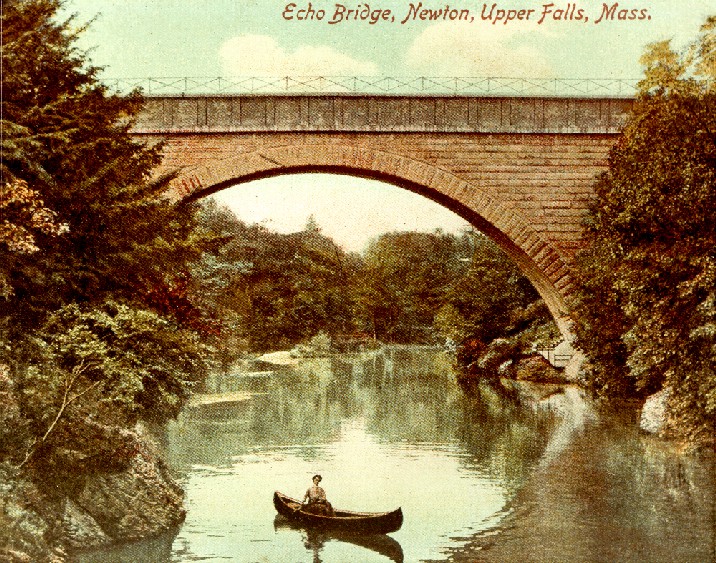
Echo Bridge

Finally we come to the beautiful structure known as Echo Bridge. It extends over the Charles River between Cook’s Bridge and the Boylston Street span. Its construction by the Boston Water Board was started in the spring of 1876 and completed in November 1877 at a cost of $200,000. During its construction no accident occurred to a workman or to the machinery.

The bridge is 500 feet in length and consists of seven arches, five of 37 feet span and one (over Ellis Street) of 38 feet. The seventh and largest arch, which spans the river is said to be the second in size on this continent and one of the largest stone arches in the world. At the time of construction its size was exceeded only by the Cabin John Bridge in Washington, D.C. It is segmental in form, 130 feet in span, with a radius of 69 feet. The crown is 51 feet above the usual surface of the water and the top of the bridge 70 feet above the river. The keystone is five feet in depth with the archstones increasing to six feet at the base forming a very heavy arch, and the pressure upon the foundation is about 2,900 tons – or about 16 tons to the square foot. The foundations of the entire bridge are in solid rock.


The timber framework upon which the arch was built rested upon five points of support in the bed of the river and demanded about 110,000 feet of spruce, oak and hard pine timber in its construction. The settling of this framework which was caused by the weight of the archstones during construction was only about, two inches. To one standing beneath it the arch has a very slender and beautiful appearance, tapering from 22 feet at the base to 18 feet in width at the crown. There is a remarkable echo within the arch with the human voice being rapidly repeated upwards of 15 times and a pistol shot 25 times.
The inside section of the conduit carried within the bridge is equal to a circle eight and a half feet in diameter, its width is nine feet and height seven feet, eight inches. The inclination of the conduit is one foot per mile and its capacity, when filled to high water mark, is 80,000,000 gallons in 24 hours. At each end of the bridge were two large iron doors lying flush with the surface of the granite topping. When opened they revealed a flight of iron rungs leading down into the conduit where a boat was moored. This was used periodically to inspect the conduit. On occasion a privileged few were allowed to go along on these inspection cruises. King’s Handbook of Newton records the adventures of one of the fortunate ones, Mary Blake. Her experience bears being told in part here:
“We were a party of adventurers, who…were allowed to go down into the main conduit of the Sudbury River water supply, where it crosses the arches of Newton, and float down under the earth till we reached the light of day again at Chestnut Hill. When the opening through which we had descended had been closed, and as we glided down the dark tunnel, with flaring lights and innumerable candles fastened in tin reflectors…the situation was novel enough to suit even a modern spectacular dramatist…(it is) a clean, well-aired, brick arched aqueduct, nine feet in diameter, with a stream of clear, pure water, two feet in depth, flowing with almost imperceptible motion through the dark silence, and losing itself in the shadows. At every hundred feet a little numbered tablet of white porcelain divided the structure into sections, so that either cleaning or repairs could be carried on systematically and quickly. The gangs of men employed in labor of this kind can be subdivided, so that the work is accomplished in an incredibly short space of time. Twice a year the entire extent is carefully scraped and washed; and a constant supervision, with telephonic communication along the whole line, and expert examination, prevents the possibility of even slight damage. Through the entire length of 16 miles manholes and ladders give easy access at stated points, and a system of underground maps corresponding to the landmarks above makes it possible to locate any break or injury with great exactness. A complicated system of screens and floodgates at both inlet and outlet filter and control the flow, so that the mighty force is as gentle as a well-bred child, when it might easily be so terrible. The exquisite compactness and neatness of the enormous structure is a marvel to unused eyes; not a drop of moisture falls from the high, clean roof; both brickwork and cement look pure and fresh as if laid yesterday, and the clear, limpid water is transparent as crystal…”
Today the system is not in full use, serving only as a standby reserve in case of a breakdown in the water supply presently being received from the Quabbin Reservoir located in the center of the state. One of the largest reservoirs in the nation, Quabbin is expected to supply our needs for many years to come. However, for almost 75 years, from 1877 to the early 1950s, Echo Bridge carried its precious cargo of the “elixir of life” to thirsty millions. Fortunately, it has been preserved and still stands today as an outstanding and beautiful example of nineteenth century engineering skill. On April 9, 1980 it was accepted by the Commonwealth of Massachusetts into the NATIONAL REGISTER OF HISTORIC PLACES.

We are pleased to announce at this writing that the state is beginning to restore some of the decaying and damaged bridgework and the Metropolitan District Commission (MDC) is beginning to bring back some of the beauty to Hemlock Gorge.
Hemlock Gorge Reservation
Hemlock Gorge which surrounds Echo Bridge is a small but beautiful reservation set apart for the public by the MDC. Dense hemlock groves and rugged rock formations mark the banks of the river, mostly on the Needham side and a steep climb from the water level brings the stroller to the west end of the bridge. From there diverging pathways lead down across rustic bridges over a small stream past caves in the ledges called Devil’s Den. These are formed in the Roxbury pudding-stone formations so called as they are believed to be made up of small stones and lava spewed out of an ancient volcano in that area.
The small stream enlarges into a pond called New Pond. Because it is so protected by banks of hemlock along its south bank, it provides the earliest skating of the winter. Before the chestnut tree blight struck this area, many giant trees of this variety provided sweet and succulent nuts for the passerby.
In 1893, on the banks of the river near the Elliot Street or Cook’s Bridge there was a recreational area established called Echo Bridge Park. This park preceded by about three years the better known Norumbega Park downstream.
Echo Bridge Park was equipped by a public-spirited citizen and a complete description is supplied by two news items appearing June 13 and 23, 1893:
“The citizens of Newton and surrounding towns now have a pleasure resort, the need of which has long been felt. The beautiful grove in the vicinity of Echo Bridge, which divides Upper Falls and Needham, has been leased to a public spirited gentleman, and under the supervision of Mr. John R. Hall, the well known architect of Boston, hundreds of workmen have within the last two months transformed the grounds into a little fairy land. Echo Bridge was built by the city of Boston many years ago as a means of conveying the large water pipes from Lake Cochituate, and is considered one of the finest structures in masonry in the country. It is also of wide special fame on account of its grand echo, which attracts hundreds of people to the spot. The architect has built two large bridges over the Charles River.”
(This may be considered as one bridge, built more or less in a “Z” shape utilizing exposed rocks in the river as supports, Ed. Click here to learn more about this bridge and the plans of the Friends of Hemlock Gorge to restore it.)
“These lead to a broad staircase, extending up the cliff 30 feet, with broad landings, to the winding pathways, shaded by stately elms, oaks and pines, direct to the center of the park, situated on an oblong shaped hill. A large dance pavilion has been erected in the gothic style of architecture, 40 x 100 feet, open on all sides, with a high pitched roof. The pavilion is enclosed, with seats extending around. The floor is of maple. Adjoining the pavilion, and extending down the slope, long rows of seats have been erected, facing the music stand. At the foot of the slope and facing the pavilion Mr. Hall has erected a two-story octagon music stand, 20 feet in diameter. The band will be placed in the second story, which commands a view of the entire grounds. The lower story will ‘be used for the refreshment stand, the shutters opening in a manner to form a roof around the building. The whole is finished with a high polished roof, with a flag staff at the top. Distributed over the grounds are some 300 seats, similar to those on Boston Common.
Accommodations have been made to seat 2,500 people. The entrance to the park is from the Newton side. Located near the entrance is an old fashioned mansion of the colonial style, and this building will be used for the sale of refreshments, conducted on temperance principles. The grounds are well supplied with swings, merry-go-rounds, etc., with lavatories for both ladies and gentlemen. These beautiful grounds were thrown open to the public last Sunday afternoon. In the evening they assumed an additional splendor by the illumination of the electric lights, casting their rays upon the whole of Echo Bridge, displaying the immense granite arches, the falls, and the beautiful winding Charles River. The new bridges were lighted with red, blue and white in large glass globes. For picturesque scenery the spot cannot be surpassed. Fern-covered rocks, the falls, umbrageous groves, precipitous banks and bridges reflected in the deep, still waters, all form one of the most charming pictures that can be imagined. The attendance was very large on Sunday evening, and an excellent concert was given by the Crescent Band of Waltham. The Echo Bridge Park, above described, is now open to the public every day of the week including Sunday. There is no quieter nor more beautiful spot in the entire city where women and children may resort during the afternoon, situated as it is in the midst of beautiful scenery, and shaded by pines and hemlocks.”
All this was made possible by the coming of the new electric streetcar railway to the village. As indicated previously, on a pleasant Sunday afternoon as many as 5,000 people came here by that means to enjoy the beautiful surroundings.
However, architect Hall’s charming creation was doomed to be short-lived. Two years later, in 1895, the Metropolitan Park Commission (predecessor to the Metropolitan District Commission) was established by the state with its purpose to create parks, scenic highways, public beaches: arid other facilities. Such a commission no doubt was inspired by the remarkable work done in the Boston area by Frederick Law Olmsted, founder of American landscape architecture. News that this eminent individual was to redesign Hemlock Gorge in a manner that would eliminate Echo Bridge Park probably was received with mixed feelings by the local populace. Yet they may have felt honored to gain the attention of a man who had designed, with his partners, 89 parks in 30 states!
His works include Central Park in New York, the grounds of the United States Capitol in Washington, the site plan for Stanford University, Mount Royal Park in Montreal, the plan of the World’s Columbian Exposition in Chicago and an elaborate system of linked parks and parkways in Buffalo.
Mr. Olmsted’s achievements in the Boston area are equally outstanding. He created Franklin Park and then proceeded to link this park in suburban Roxbury/ Boston with Boston Common, seven miles away. To do this, Olmsted drained Muddy River and transformed it into the Back Bay Fens. He connected the Fens with Commonwealth Avenue Mall and thus completed what came to be called the Emerald Necklace, an unbroken chain of green jewels comprising the Boston Common, the Public Gardens, Commonwealth Avenue Mall, the Fens, Leverett Pond, Jamaica Pond, the Arnold Arboretum and Franklin Park. At the end of Olmsted’s Emerald Necklace, beautiful Hemlock Gorge might be considered to be its pendant.
It is fitting tribute to Olmsted’s genius as it is among the last projects in which he personally participated before he became ill. The author was fortunate enough to have seen one of Olmsted’s large drawings of the area in his office before the building became an historical museum. So many of Olmsted’s creations have been ruined by freeways as well as commercial and residential encroachments that one might wish to have this untouched and unspoiled (albeit neglected) treasure, along with Echo Bridge, restored to their former glory in his honor.
Addendum
As a postscript to the above, we would like to report that at this writing the Massachusetts Water Resources Authority (MWRA), a state authority,.is making extensive repairs to the bridge, and a local group calling themselves, “Friends of Hemlock Gorge” are cooperating with the MDC in improving trails and other facilities in the park. The group is also repairing the lone existing mill building on Boylston Street which was once part of the industrial complex operating here.
At one time a bathhouse was located on the Newton side of the river near the old mills at the upper dam, and swimmers enjoyed the deep and fast moving stream at this point. The building was later moved and used as a garage or outbuilding on the property adjacent to the aqueduct south of the brick (Mazzone’s) block on Chestnut Street. Upstream were located two canoe liveries and at one time hundreds of these brightly painted craft, many with Victrolas aboard, enlivened and decorated the surface of the river. Above the Needham Street Bridge, beyond the old pumping station, was another fine picnic grove called Richardson’s Grove, later known as Cold Spring Grove. Here, and in Hemlock Gorge, many organizations such as churches, schools and volunteer fire companies enjoyed their picnics in these cool and beautiful surroundings.
It is interesting to note that in the 1870s there was a strong movement in Newton to provide more parks in the town while there was land still available. Included in sites suggested for the various villages was a certain area in Newton Upper Falls as indicated by this news item in the Newton Journal on January 7, 1871:
UPPER FALLS
Newton Journal on January 7, 1871
“There is no better place in the village to have a park than a part of that referred to in our scheme for a large park; namely, a part of the farm of Benjamin Newell, bordering on Charles River and lying between the same and Chestnut Street. Extending northerly and embracing lands of E. J. Collins, it so much is needed.”
This Upper Falls land would appear to be that which today lies within the claimed limits of the village of Waban, land bounded by Boylston Street on the south, Chestnut Street on the east, the Charles River on the west and possibly Beacon Street on the north. It was no doubt part of the Woodward farm originally, then at least partially owned by Jonathan Bixby, Benjamin Newell,* Francis Jones and finally by the Dresser family before being broken up into house lots, all properties once within the village of Newton Upper Falls. This area might have been selected for a park, since a men’s group organized in 1867 and called the Quinobequin Association is known to have laid out a golf course on part of this land prior to 1900, perhaps one of the first such courses in Newton.
*Benjamin Newell was a paper manufacturer, originally from Dover, Massachusetts who operated paper mills at the foot of Boylston St. hill, on the river. Following his occupation of the Bixby farm he built a fine home at the corner of High and Boylston streets. Later owners of the Newell estate were the Tucker, O’Malley and Mazzone families. It was badly damaged by fire and the remains torn down, a new street (Lucille Place) cut across the property and the estate broken up into house lots.
Incidentally, a newspaper account regarding this area records a drowning in 1866 that happened in “Bixby’s or Nash’s Pond. between Lower Falls and Upper Falls.” Inasmuch as the Dresser family eventually owned the Bixby land, it is possible that the pond we know today as Dresser’s Pond was known earlier by the names contained in this news item. An item in the INDUSTRY chapter indicates that Nash may have been a member of May, Nash & Winslow, glue manufacturers.