The settlement and development of Newton in the mid-seventeenth century was the result of the continuing expansion of the Massachusetts Bay Colony. Contrary to popular belief, it was not a product of the Plymouth Colony or part of the Pilgrim and Mayflower saga. Actually, the first effective impact of the Massachusetts Bay Colony on New England began when the ship Arbella finally arrived in Boston harbor in October, 1630; after stops at Salem and Charlestown in an unsuccessful search for an adequate site for a capital city (see chapter 6, THE PEOPLE). Among its passengers were members of England's well educated and influential families who, along with their strong Puritan faith were also, unknowingly, bringing the seed of democracy to America. Before the end of the year 1630, 17 more ships had made port, bringing 1,000 more of their countrymen to these shores. In ten years time almost 15,000 Puritans had arrived in Boston to make it the most populated town north of Mexico City. It was the largest immigration to the colonies until the Quaker migration to Pennsylvania in 1682-1683. By contrast, Plymouth Colony's population barely reached 1,000 persons in 1640, and by 1690 it had been absorbed into the Massachusetts Bay Colony.
Recalling that the earlier Virginia colony had enjoyed only a limited self government and that the Virginia company's charter and property had been confiscated by the Crown, the Puritan leaders of this Massachusetts colony refused to emigrate unless they could take their charter and government with them. By some influence this was possible. At a meeting of the Great and General Court (a designation that remains with us to this day) in London on August 29, 1629 they voted to move the entire company to New England. On October 20 of that year they elected John Winthrop their Governor and on March 29, 1630 he commanded the ship Arbella that sailed from Cowes, Isle of Wight with the charter and his fellow officials on board The Great and General Court had its first formal meeting in America at Boston on October 19, 1630.
With full control of his colony's charter, Governor John Winthrop established a government that for fifty years operated almost as a free state with very little royal restraint from England. By the time the mother country was aware of the strong desire for liberty and independence Winthrop had instilled in the Colony, it was too late (see footnote 1). The colors of the British flag had already began to dissolve into what eventually would be the Stars and Stripes. Later James Russell Lowell would declare, "Puritanism, Believing itself quick with the seed of religious liberty laid, without knowing it, the egg of democracy."
The Great and General Court which had been installed immediately by Winthrop called for stated elections by all government officers, including the governor himself. By example, it became a government that eventually would be copied in principle by all 13 colonies. Also, the establishment of the town meeting form of government in the villages that had sprung up around Boston was an innovation hardly dreamed of in the monarchy they had left across the sea.
Often called the "Moses of New England," John Winthrop was born on January 12, 1588 at Edwardston, Suffolk, the son of Adam and Anne (Browne) Winthrop. His father was a lawyer associated with the University of Cambridge, and his two grandfathers were prosperous cloth merchants from whom he received a large inherited estate, much of which he spent for the welfare of the colony. It is said that "his faith, energy, and devotion to the public weal left a rich heritage to the Commonwealth of which he was the principal founder; and when Massachusetts was asked to place one statue in the Hall of Fame at Washington, she wisely chose John Winthrop as the finest representative of her ideals and achievements." Winthrop died March 26, 1649 and was buried in King's Chapel Burying Ground, Boston.
Perhaps credit for whoever or whatever made a nation such as ours great should never be awarded entirely to one generation - yet there is a certain quality about some of the first settlers who landed on our New England shores that illuminates the opening pages of the journal these pioneers left behind
Almost all of our villages in New England, particularly those in the Boston area, were born under the influence of that first generation, Newton Upper Falls was among them.
The continuous arrival of new settlers soon taxed the facilities and available home sites in and around Boston. Almost overnight new settlements began to appear all along the shoreline of New England, north and south. Among them was Cambridge, home of Harvard College, located just across the Charles River. Because of its close proximity to Boston it became a "holding ground" for many of these new immigrants seeking home sites, which prompted the Great and General Court to grant the village additional territory to accommodate the new arrivals. This new land acquisition included all of what was to be Billerica, a large portion of Bedford, a section of Lexington and all of Arlington, Brighton and Newton (the area taken by grant from Watertown and given to Cambridge in 1635).
Surprisingly, Cambridge with the advantage of having access to the additional territory granted it by the legislature did not appreciably increase its population until late in the eighteenth century after the Revolutionary War. Whatever growth it did experience was reduced by secession of a number of expanding townships just inside its borders. There were also noticeable departures from the area when large companies of new arrivals from England found greener pastures in places as far away as Connecticut. When Newton launched what was to be a long struggle to cut its ties with the parent village, Cambridge's concern for its increasing loss of tax support by previous secessionists fired their resolve to retain the territory sought by its latest adversary. Their resentment bore some justification as it thinned the ranks of taxpayers needed to support the maintenance of its recently completed school, a bridge over the Charles River and a number of highways. The battle for separate village status was fiercely fought and was marked by many bitter and lengthy political battles in the General Court.
Not all the adversaries were former Cambridge residents as, contrary to some historical records, many settlers who came into Newton (Cambridge Village) in the late 1600s were from a number of areas around Boston. (See p. 40-41, SMITH'S HISTORY OF NEWTON).
It is interesting to note that these "secessionists" by seeking to acquire this large unsettled section of Cambridge were circumventing the colonial requirement for the establishment of a new village. Normally permission for the establishment of a new town had to be obtained from the General Court and was usually for a land plot of approximately six square miles adjoining an older town. New settlers were required to lay out a main street, the village green, the centrally located church, a school, the town lots and fields or strips adjacent to the settlement before the village was recognized by the government. Failure to have done this may be the reason Newton has never had a Main Street" or a "core" village in the city.
Newton was finally recognized as an independent village (New Cambridge) in 1688, but minor skirmishes continued for some time and the acrimony attending the split with Cambridge may have had some bearing on Newton's unusually slow development. The growth of this large tract, approximately 18 square miles in area, lying but a few miles west of Boston, remained dormant for a century, and Newton's population remained small. At the time of the Revolutionary War there were only 1,300 persons living in the Town. Newton's population figures bear evidence of its slow growth:
Newton's move for independence may have been a little premature. Most of our early villages were located on the seacoast, and the ocean was the prime source of their livelihood. Historian Samuel Eliot Morison tells us, "As late as 1730…a farm could not be found more than 30 miles from the sea." Newton found itself landlocked and lacking an abundance of rich soil for productive farming as well as heavy stands of timber suitable for lumbering. Settlers had to fall back on keeping livestock, mainly flocks of sheep. Without adequate highways trading was difficult.
However, along its shores north and south of Boston as well as in a northwest and southwest direction, the Massachusetts Bay Colony experienced a rapid expansion, mostly from immigration. Approximately half a million people were living in New England by 1750.
Perhaps the limited access to Boston also had some bearing on Newton's slow development. Virtually an island at high tide, for some 150 years access and egress to the city was either over tidal flats through Roxbury or by an occasional ferry from Cambridge. It appears that the early generations of Newtonians rarely visited the area's largest metropolis less than 10 miles away. Few or no carriages at all existed, and the only wheeled vehicles were crude, homemade affairs used mostly about the farm.
The first church in the area, founded in 1661 at East Parish (Newton Centre), was the traditional church of the Puritans. (See Chapter 8, Churches), We shall learn later that the principal reason for its location was a gift of land for its site by a local resident. This church was actually the third church in the town of Cambridge, as its location would still be part of that town until 1688, when the area was officially separated from the parent township. However, after the separation and following tradition as a "state" church it would become the seat of town government. It did not boast of a large congregation in the beginning, being made up of about 30 families consisting of 80 people. Fifteen years earlier, in 1645, an old Book of Records reveals that in that year 135 persons were subject to village taxes. (Also 90 houses were subject to taxation). Despite the church's request that its people live within one half mile of the church, most of the members sought out the land that was the most productive. With such a sparse population it would be some time before any semblance of a village was formed. Areas such as Upper Falls would be occupied by only two or three families.
When Newton was set aside from Cambridge, by agreement the proprietors of Cambridge agreed to reserve common lands in the southwest part of the town. However, while there was land for smaller farms owned by settlers, most of the region was available for large grants to speculators and some of the more prominent citizens were the first to benefit. John Haynes, a Cambridge resident, in 1634 was granted one thousand acres including what is now Crystal Lake, the grant extending from Upper Falls to Institution Hill. The westerly border of the huge rectangular shaped grant passed north and south across the junction of the present Elliot and Mechanic streets. Haynes never occupied the land as later he was to see a richer prize beyond the western horizon. He tarried long enough, however, to become Governor of Massachusetts before he moved to Connecticut in 1636, becoming the governor of that state in 1639. He died in 1654 and, his land in Newton passed to his heirs. The transaction covering the original grant in Massachusetts is recorded as follows from the records of the General Court, April 1, 1634:
| "There is one thousand acres of land and a great pond [Crystal Lake] granted to John Haynes, Esq.; five hundred acres to Thomas Dudley, Esq. ---- acres to Samuel Dudley, and two hundred acres to Daniel Dennison, - all lying and being above the Falls on the east side of Charles River, to enjoy, to them and their heirs forever..." |
 Thomas
Mayhew of Watertown was another who was active in the town's
development. He was able to secure a grant of the weir lands on
the south side and acquired two large holdings further south, one
of which contained, 500 acres south of the weir lands extending
to the "region of Mill Street." The other lay between
the Haynes grant and the the river at Upper Falls (which would
include the village proper). Mayhew sold his property in 1638 in
order to buy the island of Martha's Vineyard
Thomas
Mayhew of Watertown was another who was active in the town's
development. He was able to secure a grant of the weir lands on
the south side and acquired two large holdings further south, one
of which contained, 500 acres south of the weir lands extending
to the "region of Mill Street." The other lay between
the Haynes grant and the the river at Upper Falls (which would
include the village proper). Mayhew sold his property in 1638 in
order to buy the island of Martha's Vineyard
In 1658 John Kenrick moved to Newton from Boston and purchased 259 acres formerly owned by Thomas Mayhew along the river beyond the Haynes grant, in the section where Kenrick's (now called Kendricks) Bridge perpetuates his name. His great, great granddaughter, Anna Kenrick in 1789 married General Benjamin Pierce, a Revolutionary War officer and had a son, Franklin, who became the l4th President of the United States. John's land made up the southern limits of the area over which the village of Upper Falls would have any influence. Early settlers on the northern perimeter of the village included John Woodward in 1681 and John Staples in l688. However, it would be John Clark who changed the course of Newton's development. It was he who accelerated, the pace of the town's industrial growth when in 1688 he established the first industry on the Charles River in Newton, a sawmill at Newton Upper Falls. It was his enterprise that thrust Upper Falls into a leading position in industrial expansion in the greater Newton community.
Only by a caprice of Mother Nature was Clark's enterprise made possible. About 10,000 years ago a glacier that had inched its way southward as far as Long Island Sound was halted by a strange warming of the climate which forced it to retreat northward When its passage was delayed by rocky heights, new called Prospect Hill in Upper Falls, it is said that its awesome facade loomed nearly a mile above the ledge upon which it rested. Melting ice and snow cascading down its face smashed into the rocky mass below. The ledge, composed of mixed lava and loose stone spewed out of an ancient volcano somewhere in the Roxbury area, began to show effects of this assault.
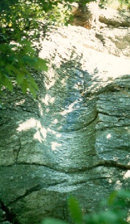
|
The "Upper Falls Pothole" |
Evidence of its tremendous power can still be seen in the ledge located on Sullivan Avenue, just a few feet from Elliot Street. Called the "Upper Falls Pothole," one can observe what is half of a smooth, bored hole carved in to the ledge which was produced when a granite boulder, lying in a pocket on top of the ledge, was caught in the glacial downpour causing it to rotate within its cavity. Acting like an auger or drill, it bored its way through the ledge and later when the deluge tore away half of the hole, it left behind, the other smooth half, exposed as we see it today.

The glacial floods reaching lower ground continued to tear their way through the softer earth and rocky ground as they sought the nearby sea. As a result, when a meandering river sought this selfsame sea it took advantage of the descending gorge we know as Hemlock Gorge, and rapidly dropped 26 feet in the few hundred feet of its length. In all of the 79 miles the Charles River wanders to reach Boston Harbor, located but 26 miles from the river's source, this gorge represents the largest drop in the river bed. John Clark was the first to harness its power and his mill marked the birthplace of Newton Upper Falls
 Fortunately, Clark found
the Algonquian tribe of Punkapoag Indians at his mill site
friendly and willing to sell some of the territory for the
location of his dam and mill. It was a beautiful site, the deep
ravine studded with huge hemlock and tamarack trees past which
the river tumbled over its rocky ledges northward toward the sea.
The stream teemed with fish and the Indians long before had made
this their favorite fishing grounds, setting up their weirs from
bank to bank. They had named it "Quinobequin" (the
river that circles around). Later, when John Smith was mapping
the coast of New England, he would rename it the
"Charles" in honor of Charles I of England
Fortunately, Clark found
the Algonquian tribe of Punkapoag Indians at his mill site
friendly and willing to sell some of the territory for the
location of his dam and mill. It was a beautiful site, the deep
ravine studded with huge hemlock and tamarack trees past which
the river tumbled over its rocky ledges northward toward the sea.
The stream teemed with fish and the Indians long before had made
this their favorite fishing grounds, setting up their weirs from
bank to bank. They had named it "Quinobequin" (the
river that circles around). Later, when John Smith was mapping
the coast of New England, he would rename it the
"Charles" in honor of Charles I of England
It is said that salt water from the sea at high tide penetrated inland as far as the dam at Upper Falls, bringing with it salmon, shad and alewife. These, combined with the fresh water varieties of fish in the stream above the falls, made it a very desirable habitat for the Indians. They took advantage of the narrowed channel of the river confined as it was by the craggy ledges of rock, to set up their fish weirs. From the "Story of our Town" (Needham) by Mildred Barney Talmadge, we learn how it was done:
| "…The river was a source of food for the Indians. It is known that they had a fish weir at the Upper Falls. It is thought that they cut large branches of saplings and trimmed off the lower branches leaving the upper ones, making something not unlike a big broom. There would be several canoes with an Indian at the bow of each, holding one of these big brushes. With an Indian paddling each canoe they would start way up the river and drop the brush end of these poles well into the water. Then they would paddle down stream sweeping the fish before them. At a narrow place in the river above the Upper Falls the squaws would be ready with nets woven out of reeds. The fish would be driven into them and dragged up on the bank. There the Indians would build fires, smoke the fish and lay them away in a cave to be eaten in the winter." |
And from King's Handbook of Newton, concerning these weirs:
There is a story that an early group of settlers from Watertown pushing their way up the river by boat in 1636 were terrified by the waters rushing through this gorge, darkened by the hemlocks. The "savages" lurking in the shadows also discouraged them, and they continued on up the river until they came upon the open meadows of the place they would call Dedham. By coincidence, it was the proprietors of Dedham who some years later, in April 1680, desired to purchase some land owned by these Indians and arranged a deal with the chief of these same savages they had encountered earlier. They agreed to give the chief, William Nehoiden (Nahaton), ten pounds in money, 40 shillings worth of Indian corn and 40 acres of land, 120 rods long and 53 rods wide, at the Upper Falls on the Charles River in exchange for a tract of land seven miles long from east to west and five miles wide, now the township of Deerfield. The same year they gave Maugus (also a chief) eight pounds for his land down river at a place called Maugus Hill.
However, Nahaton sold his land as we note from the record of January, 1700:
| "William Nahaton, an Indian, of Punkapoag, for twelve pounds conveyed to Robert Cook, of Dorchester, horn breaker, forty acres of land on the west side of the Charles River, just above the Upper Falls, one hundred and twenty rods long and fifty-three rods wide." |
(The occupation of horn breaker is unknown.) Regarding the land Jackson says:
| "This is the same land which the inhabitants of Dedham conveyed to William Nehoiden (Nahaton) in April 1680." |
Clarke's History of Needham supplied this information regarding Robert Cook:
| "Cook was born in Boston (Dorchester) and his father's name was also Robert. The younger Robert, later acquiring the military title of Captain, was considered one of the most prominent citizens of Dedham and later of Needham when it became an independent town in 1711. He was a surveyor of highways in Dedham in 1706, a constable in 1709 and elected a selectman in 1710." |
Although he was among the first settlers of Needham, his farm was "near Cook's Bridge at Upper Falls," (see footnote 2) and he no doubt was involved in affairs of that village also. He died April 1, 1756, aged 86, and is believed to be buried in the old graveyard On Nehoiden Street in Needham.
We continue with the historic background of the negotiations involving the sale of land on the west bank of the river. The colorful language, the exciting descriptions and, unusual clauses, as well as other language quirks found in the early deeds and depositions covering these transactions make fascinating reading.
The care with which the deed of Nahaton and these depositions were drawn and have been preserved indicates the high value set upon the property in the vicinity of the Falls. We heartily agree with our historian when he states the "the Deed and Depositions themselves are of sufficient interest and importance to claim a place in these Records." And so they are recorded here.
To all people unto whom these presents shall come. William Naahaton, an Indian of Pukapoge, within the County of Suffolke, in the Province of the Massachusetts Bay, in New England, - Sendeth Greeting.
Whereas the Inhabitants of the Towne of Dedham, in the County afores'd, on the Fourteenth day of the Second Month, 1680, Granted to the s'd William Nahaton and to his heires forever Forty acres of Land, Lying abutting upon Charles River towards the Northeast, one hundred and Twenty rodds Long, just above the Upper falls, fifty three Rodds in breadth, and abutting upon Dedham Land on all other parts, - With Liberty of fishing at the s'd William's Weares, Provided he or any of his successors shall not have Liberty to sell or dispose of any of the abovesaid Premises to any man without the consent of the Selectmen for the Towne of Dedham for the time being, - as by the said Towne Grant, reference whereto being had more fully may appeare.
And whereas the said Selectmen of Dedham for the time being have granted unto the s'd William Nahaton their free consent and liberty to dispose thereof unto Robert Cooke, of Dorchester, in the County of Suffolke, afores'd Hornebreaker, the surviving son of Robert Cooke, late of Drchester afores'd, Hornebreaker, deceased
Now Know Yee that I, the s'd William Nahaton, for and in Consideration of the Summe of Twelve Pounds Current Money of New England, to me in hand well and truely payd att and before the ensealeing and delivery of these presents by John Hubbard, of Boston, in the County of Suffolke aforesaid, merchant, for account and on behalf of the s'd Robert Cooke, the receipt whereof to ffull content and satisfaction I doo hereby acknowledge, and thereof, and of every part and parcel thereof doo acquitt, exonerate and discharge the s'd John Hubbard and Robert Cooke and each of them, their and each of their heires, Executors, administrators and assignes forever by these presents Have given, granted, bargained, sold, aliened, enfeoffed, conveyed and confirmed, and by these presents Doe ffully, ffreely, cleerly and absolutely give, grant, bargaine, sell, aliene, enfeoffe, comveye and confirme unto the s'd Robert Cooke, his heires, and, assignes Forever, All The aforementioned fforty Acres of Land Lying within the Towneship of Dedham granted unto me as afores'd, and bounded and described as afores'd, Together with all profitts, privilidges, rights, commodityes and appur'ces whatsoever to the same belonging or in any wise appertalning. And the revercion and revercion remainder and remainders, rents, issues and incomes thereof, And also all the Estate, right, title, Interest, Inheritance, use, possession, property, claime, and demand whatsoever of me, the s'd William Nahaton, of, in and to y'e same and every part thereof, reserving only out of the above granted premises unto me, the s'd William Nahaton, my heires and assignes forever, one quarter of an acre of s'd land for the accomodation of Fishing by or neare unto the afores'd Weares,-
To have and to hold the s'd Forty acres of Land, bounded and discribed as afores'd, with the priviledges and appurten'ces thereunto belonging (reserving only as above reserved), unto the s'd Robert Cooke, his heires and assigns, To his and their owne sole and proper use and benefitt and behoofe forever, absolutely, without any manner of Condition, redemption or revocation in anywise. And I, the s'd William Nahaton for me, my heires, Executors and Administrators doo hereby covenant, promise, grant and agree to and with the s'd Robert Cooke, his heires and assignes, in manner and Form following, That is to say, That att the time of the ensealing hereof and untill the delivery of these presents. I, the s'd William Nahaton, am true, Sole and, Lawfull owner of all the aforebargained premises, and stand Lawfully seized thereof in my owne proper right of a good, sure and Indefeasible Estate of Inheritence in ffee Simple, Haveing in myself Full power, good right and Lawfull authority to grant, sell, convey, and assure the above granted premisses with the appurt'ces (reserving as above reserved) unto the said Robert Cooke, his heires and assignes forever, in manner and Forme afores'd, and according to the true Intent and meaneing of these presents, And that the s'd Robert Cooke, his heires and assignes, shall and may by force and virtue of these presents, from henceforth and Forever hereafter Lawfully, peaceably and quietly enter into and upon, have, hold, use, occupy, possess and enjoy the abovegranted and bargained premisses, with the appurt'ces, reserving only as above reserved, ffree and cleerly acquitted, exonerated and discharged of and from all and all manner of former and other gifts, grants, bargaines, sales, leases, releases, mortgages, joyntures, dowers, judgements, executions, entails, forfeitures, seizures, amorciaments, and of and from all other titles, troubles, charges and Incumbrances whatsoever. And Further, That I, the s'd William Nahaton, for me, my heires, Executors and Administrators, and every of us doe hereby covenant and grant to warrant and defend all the above granted and bargained premisses, with the appurt'ces thereof (reserving only as above reserved), unto the said Robert Cooke, his heires and assignes forever, against the Lawfull claimes and demands of all and every person and persons whomsoever. In witness whereof, I the said William Nahaton, have hereunto sett my hand and seale the Twenty-ninth day of January anno Dom'i one thousand seven hundred, In the Twelfth Yeare of the reigne of King William the Third over England, &c.
WILLIAM NAHATON (SEAL)
Signed, Sealed and Delivered in the presence of us
A------- LEANHARD
Signum
A
ABRAHAM BLANCHARD
ELIEZER MOODY, sct.
Suffolk ss. Boston, January 29th, 1700.
The above mentioned William Nahaton, personally appearing before me the subscriber, one of his Majesty's Justices of Peace within ye County afores'd, acknowledged this Instrument to be his free and voluntary act and deed.
EPHR. HUNT.
Memo. It's to be understood That there was formerly a deed given by the s'd William Nahaton for the piece of land above mentioned; which deed being lost, this was againe given.
The depositions which follow furnish further evidence, in the absence of written records, of the possession of the property by the original owners, and of the right of the Indian to convey it to the white proprietor.
Stoughton, January ye 4th, 1747.
The Deposition of Amos Nahaton, of Eighty-two years of age, doth testify and say that I well remember my Father, William Nahaton, of Punkapog, owned the Great Falls in Charles River, and that he owned the s'd River for a great ways above and below s'd Falls, and the Islands and Eell wares in s'd River, and that he owned the land against s'd Falls on the West side of the River. And I further well remember Above sixty years past, My Father sold A piece of land called two acres at the Great fishing place on the West side the River for A Gun to John Maugus, of Natick, and that the s'd Maugus was to have Liberty to fish at My Father's Mares in s'd River; and I further Testify That when My Father sold A certain Piece of land to Cook or Cook's Mother, that he did not then sell Maugusses land nor the Islands nor the wares in s'd River; further, I Testify that above sixty years past John Maugus and the other Natick Indians were then In the Possession of the above two acres, and had Wigwams on s'd land
his
AMOS + NAHATON
mark
Stoughton, Jan'ry ye 4th, 1747.
The within Deponent, Amos Nahaton, Took his Oath to the within Deposition in Perpetuam Rei Memoriam before us
SAMUEL WHITE, Justice of the Peace
Quorum Unus
HENRY SEMALL, Justice Peace
N.B. The within Deponent at the time of Caption was Esteemed by us to be of Good Judgment and Sound Memory.
SAMUEL WHITE,
HENRY SEMALL
I Sarah Tray, of Natick, of above fifty years of age, do Testify and say that I often heard my Husband's Grandmother Maugus often say that her husband, John Maugus did once own that peice of land on the west side of Charles River at the fishing place at the upper falls, which the Indians did improve, and the Rock House; and that her Husband Maugus had a Wigwam on s'd piece of Land, and that he gave said land to his Daughter Catherine. I further Testify that my Husband's Mother Catherine used to say that her Father Maugus gave her the above piece of land, and that my Hudsband's Father and she had a Wigwam on s'd land, and lived there; and I have often heard my Mother Catherine say that the English Man that Built the Mills purchased the privilidge of the Indians at s'd Falls; and I further say that I well remember that my Mother Catherine and Samuel Abraham used to Improve s'd land and the Rock House on s'd land by cutting Wood, making fires, drying fish and Eels for forty years past.
her
SARAH + TRAY
mark.
Suffolk, ss. May ye 20th, 1748.
Sarah Tray, of Natick, Indian, above named, made oath to the truth of the above written Deposition in Perpermam rei memoriam.
| Before us | SAMUEL WHITE | Justices of the Peace |
| HENRY SEMALL | and Quorum unus |
I Ebenezer Mare, of Needham, in the County of Suffolk, and province of the Massachusetts Bay in New England, Yeoman, Testifie and say that above Seventy Years ago I knew a certain Eale-Ware in Charles River, Just above the upper falls in said River. I knew said Eale-Ware to be Improv'd above Twenty Years; and I further Testifie that about Seventy years ago John Clark, Senior, of Newton, Dec'd, told me he had Bought all the Indians' Right at the Upper falls for a Conveniancy to Build Mills thereon; and furthermore I testifie and say that John Clark Junior, Dec'd. told me that his Father Bought the above said Ele ware, and gave three Pounds for the same, The said Ele ware was in the River just above the foord way, which I and the Nighbours used to pass over in, and below where the Cart Bridge now stands; and, Furthermore, I testifie and say, as I used to pass by said ware frequently, that According to my Best Remembrance, the Stone Walls of said Ware was about three feet from the Botom of said River in hight when in Repare for Fishing; and furthermore, I, for near seventy years Past never heard any Person or Persons Lay Clame to said Ware, But the above named Clarks and the Owners of the Grist Mill at the upper falls.
his
EBENEZER + WARE,
mark
Suffolk, ss., Octo'r 21th, 1763.
The above named Ebenezer Mare mad Oath to ye truth of ye above Deposition in Perpetuam rei memoriam.
Before us,
| ELIPH'T POND | Justices of ye Peace |
| ISAAC GARDNER, JUN'R | Quorum Unis |
DEPOSITION OF JEREMIAH WOODCOCK
I Jeremiah Woodcock, of Needham, in the County oi Suffolk, and Province of Massachusetts Bay, in New England, Yeoman, Testifie and say that I knew a Certain Eleware in Charles River, Just above the upper falls in said River, I knew said ware improved for several years for fishing; said ware was in the River, Just above the foordway in which I us'd to cross the River in, Just below where the Cart Bridge now stands, that according to the Best of my Remembrance When in Repare for Fishing, the Walls of said Ware were three feet in height; and also I heard Fifty years ago, the Clarks, then of Newton, were then the owners of said Eleware.
JEREMIAH WOODCOCK
Suffolk, ss., Octo'r 21st, 1763.
The above named Jeremiah Woodcock made Oath to the truth of ye above Deposition, in Perpetuam rei memoriam.
Before us,
| ELIPH'T POND | Justices of y'e Peace |
| ISAAC GARDNER, JUN'R | Quorum Unis |
Eliakim Cook, of Needham, in the County of Suffolk, and William Clark and Joseph Chaney, of Newton, in the County of Middlesex, all in the Commonwealth of Massachusetts, Living Near the Great Falls Called the upper falls in Newtown, Severally testify and say that in more than Sixty years that wee have been Conversant with the River and fishery about said falls, and that wee Never New aney Salt water fish to assend above said falls, nor do we Remember Ever to have heard our Predessors say that aney Salt water fish did ever assend above said falls. Further we say, and Give it as our Opinion, that it is Impracticable for the fish to Assend said falls ever while wee consider it in the State of Nature.
ELIAKIM COOK,
WILLIAM CLARK,
JOSEPH CHENEY.
Middlesex, ss., February 2, 1790.
Eliakim Cook, William Clark and Joseph Chaney made Oath to the truth of the above Deposition before me.
JOHN WOODWARD, Justice of the Peace.
The few white settlers who occupied the village of Newton Upper Falls following the erection of John Clark's sawmill in 1688 did not start a housing boom, and though a grist and fulling mill soon followed to form Newton's first industrial complex it did not immediately generate similar developments except those of its downstream neighbor, Newton Lower Falls. However, the population of Newton remained dormant while Upper Falls commenced to grow. It is a moot question as to when it went from the status of being a settlement to that of a village. One historic account has led to an erroneous assumption that only about six families were living here in the year 1800. Certainly, in 1778 and 1782 when Simon Elliot of Boston in two purchases acquired the century old sawmill, grist mill and fulling mill and erected snuff mills, a screw factory, wire mill, blacksmith and annealing shop as well as a homestead, there had to be some one to run them. Also, Rufus and David Ellis began their rolling mill business in 1799 which further boosted the need for more employees. Several farms scattered about the outer limits of the village surely would add to the number of residents in the village.
One of the more important pieces of evidence of the size of the place in 1800 is the fact that in 1802 the people of the village had joined with the residents of the Oak hill area in establishing a common burial ground at the junction of the present Winchester, Dedham and Needham streets (now the oldest non-sectarian cemetery in the city).
There is no doubt that the growth of the village began to accelerate at the turn of the century. More than one-third of the gain in Newton's population from the year 1781 to 1850 (see population chart) took place in Newton Upper Falls. Other records indicate that of the 5,238 persons living in Newton in 1850, 25% of these (1,300 people) were located in Upper Falls. The records of Matthias Collins III, Town Treasurer of Newton during the early days of the nineteenth century, show that about two-thirds of the town tax valuations were located in Upper and Lower Falls. It is estimated that there were more than 50 homes in Upper Falls in 1831 and about 130 in 1855.
While the geographical borders of the early villages of Newton are difficult to define (as they are today), Upper Falls for two centuries was a large and sprawling community. Early records indicate that its borders could be defined as follows: on the north by the area that now includes Waban Square, on the east by the western shores of Crystal Lake; Naha(n)ton Street on the south; and with the Charles River as its western border. The outer perimeter of the village vas sparsely settled with only about seven families residing in the area now Waban: the Turners, Collins, Wiswalls, McNoahs, Allens, Davenports and Woodwards. Records show they were quite active in the affairs of the village, especially with those of its first church. Among the petitioners in the organization of the Upper Falls Religious Society's meeting house in 1827 were Matthias Collins, William Wiswall II, and Bethuel Allen. Included in the list of members were Nathaniel D. Turner and several members of the Woodward family.
Waban did not gain village status until after 1886 (Its post office was established in 1891). In 1830, to the east in what is now Newton Highlands, there was only Craft's blacksmith shop and Mitchell's tavern. Early village border lines of Newton Highlands are difficult to define. An article appearing in the TOWN CRIER of October 13, 1905 indicates that an Ebenezer H. Greenwood, "the first settler in what is now Newton Highlands" passed away at his home at 68 Hartford Street. Mr. Greenwood was born in Needham 78 years before, coming to Newton Highlands 40 years prior to his death which would indicate that the village proper was first settled in 1865. Its first school, the Hyde, was in the Upper Falls School District for many years after its establishment.
Only about a dozen or so families occupied the Upper Falls southern border area which included the Parkers, Winchesters, Wards, Eatons, Stones, Kenricks and Halls. This area, settled in 1658 and now known as Oak Hill, long was associated with Upper Falls and in 1802, as previously indicated, joined with them in the laying out of a common cemetery at the junction of Dedham, Winchester and Needham streets.
Before we close this section of our history we would like to call attention to another area which has been closely associated with the village of Newton Upper Falls, and still maintains at least sentimental ties with the older community. For more than two centuries (beginning with Cook's farm) a compact but rather sizable settlement located in Needham, across the Charles River from Newton Upper Falls, bore this village's name with the Upper Falls post office serving the area until sometime in the 1930s. Early official atlases of Needham designate this area as Newton Upper Falls, and Clarke in his History of Needham refers to it as the "Newton Upper Falls" section of Needham. With its dependence on Upper Falls for its mail, fire protection, marketing needs, and most importantly, for employment in its mills for so many years, it is easy to understand that the residents found more in common with Newton than with a town whose business center and other facilities lay so far away. Evidence of this close association is indicated in the fact that the bronze plaque on the stone monument at the Emerson School grounds bears the names of those who served their country in World War I and who lived in this section of Needham.
Today the village of Newton Upper Falls looks much the same as it did a century ago. Still standing are about 118 of the approximately 150 houses built more than 100 years ago, with the oldest dating back to about the year 1734. With one or two exceptions, no modern structures dominate the simple architectural austerity of these nineteenth century residences. One wonders how this place, barely ten miles from the city of Boston, has escaped the wrecker's ball and the development planners. That this industrial New England village of bygone days - one that has contributed so much to the development of Newton and through its products to the world - is still standing is remarkable.
It was therefore appropriate that the city recognize its historical value, and in December 1975 it voted to make a portion of the village an historic district. At that time the district was defined as bounded on the north by both sides of Boylston Street, on the west by the Charles River including Cook's Bridge, on the east by both sides of High Street and on the south by Elliot Street (north side only from the river to Oak Street) south on Oak (including west side to and including #23 and then across Oak to include the stone barn and adjacent store house on Cliff Road, returning to Elliot Street. It continues along the south side of Elliot to Mechanic except for the last two houses on. the north side west of Cottage Street.
In 1985 a number of other structures were included, in this group and it is hoped more will be added in other areas in the future, bringing closer the possibility that the nineteenth century New England mill village of Newton. Upper Falls may be completely preserved.
Footnote 1:
England canceled the charter of the Massachusetts Bay Colony in
1684 and sent Sir Edmund Andros to govern the colony but shortly
after his arrival came the English revolution and Andros was
ousted In 1689 the Reverend Increase Mather was sent to England
as agent of Massachusetts to secure a new charter.
Reverend Ichahod Wiswall (Dorchester born, son of Elder Thomas Wiswall, who moved to Cambridge Village [Newton] about 1654) was pastor of the Duxbury Church. He also was sent to England as agent for the Plymouth Colony to obtain a charter for that colony. Mather supposedly feared at that time New York was endeavoring to annex Plymouth Colony to New York and successfully sought a charter that would include Massachusetts, Maine and Plymouth united, an act that understandably established some animosity with Reverend Wiswall. However, as an appeasement the General Court of Massachusetts in June 1694 voted Reverend Wiswall 60 pounds "as gratification for his services in his voyage to England" Later his son, in view of this service in the cause of the Province, secured a grant from the General Court of 300 acres of land in his father's name. (From Francis Jackson's HISTORY OF THE EARLY SETTLEMENT OF NEWTON, Boston: Stacy and Richardson, 1854). Back to the Main Text.
Footnote 2:
Cook's Bridge is still the official designation of the bridge by
both Needham and Newton. Back to the
Main Text.
Copyright 1997, 1998 Kenneth W. Newcomb and The Friends of Hemlock Gorge. All rights reserved. This page last modified October 8, 1998.
To the Next Chapter, "Industry" | To the Previous Chapter, "Preface" | To the Table of Contents